In the past 45 years, Phillip Islanders have defended “their bay” against a nuclear plant, an oil refinery, a canal development and a ferry terminal. The Port of Hastings development is the latest threat to the bay, writes ANNE DAVIE.
December 6, 2013
WHEN George Bass sailed into Western Port in 1798, he found a bay measuring 40 kilometres from north to south and 35 kilometres across, with the middle occupied by French Island.
Western Port in its primitive state was a fertile breeding nursery area for a variety of marine life. Aboriginal people visited the bay, including French and Phillip islands, to gather fish, eels, shellfish and crustaceans.
When the mangroves were first mapped in 1842, there was an almost continuous fringe around the northern part of the bay, including the north coast of French Island.
In 1968, concern about a proposed marina in the Rhyll Inlet led to the formation of the Phillip Island Conservation Society (PICS).
Since that time, the society has sprung into action in many ways and at many levels to safeguard the bay. (All this is documented in An Island Worth Conserving).
Perhaps it’s timely to reflect on some of the threats to Western Port over the years.
In the 1960s the society was alarmed by comments from the then Victorian Premier Henry Bolte that Western Port was to become Victoria’s Ruhr Valley. There was talk of a nuclear power station on French Island.
We are now alarmed by comments from the current Premier, Denis Napthine, that the Port of Shanghai, the world’s busiest port, could be a model for the Port of Hastings.
In 1988/89 PICS successfully campaigned against inappropriate canal development on the Ventnor beach.
In 1993, when the Crib Point terminal was proposed, PICS convened a public meeting which led to the establishment of the Western Port Peninsula Protection Council.
An oil spill prevention and response plan at that time identified 16 sites of zoological significance in Western Port, 48 sites of avifauna and fauna areas of population concentration, 19 high tide roosting sites for wading birds, 16 sites of botanical significance, 166 sites of archaeological significance on Phillip Island and three at Corinella, and two international, five national, 41 state, 40 regional and 10 local sites of geological significance.
In 2001, the Western Port seagrass partnership was formed to address the loss of seagrass around the bay.
In 2010, PICS convened a public meeting in response to a ferry terminal proposed on the Cowes foreshore. The community believed the priceless northern family beach at Cowes was at risk for a project of no economic benefit to the island. Bass Coast councillors acknowledged the community opposition to the project and rejected it.
Now, with the plan to develop Australia’s biggest container port at Hastings, the next chapter in the Western Port story has begun.
PICS’ greatest concern has always been about oil spills and the impact of dredging. Given the six-eight tides that flow in and out of the bay every day, we believe everyday dredging on any large scale will seriously damage the coastline in the path of these tides.
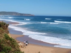
Most of us who live on Phillip Island have an affinity, affection and respect for the values of Western Port, the front door, as it were, of our home.
The redevelopment of the Port of Hastings has the potential to diminish our way of life, harm the special ecological values of the bay and wreck the local tourist economy.
PICS has a passion and commitment to a healthy viable Western Port. It looks forward to mandatory commitments by the Port of Hastings Authority to an environment effects statement and an economic impact statement so the conversation can really begin.
This is an edited version of a presentation made to the CEO of the Port of Hastings Authority, Mike Lean, last Monday on behalf of the Phillip island Conservation Society. In response, Mr Lean undertook to meet PICS members in February.
Timeline
WHEN George Bass sailed into Western Port in 1798, he found a bay measuring 40 kilometres from north to south and 35 kilometres across, with the middle occupied by French Island.
Western Port in its primitive state was a fertile breeding nursery area for a variety of marine life. Aboriginal people visited the bay, including French and Phillip islands, to gather fish, eels, shellfish and crustaceans.
When the mangroves were first mapped in 1842, there was an almost continuous fringe around the northern part of the bay, including the north coast of French Island.
In 1968, concern about a proposed marina in the Rhyll Inlet led to the formation of the Phillip Island Conservation Society (PICS).
Since that time, the society has sprung into action in many ways and at many levels to safeguard the bay. (All this is documented in An Island Worth Conserving).
Perhaps it’s timely to reflect on some of the threats to Western Port over the years.
In the 1960s the society was alarmed by comments from the then Victorian Premier Henry Bolte that Western Port was to become Victoria’s Ruhr Valley. There was talk of a nuclear power station on French Island.
We are now alarmed by comments from the current Premier, Denis Napthine, that the Port of Shanghai, the world’s busiest port, could be a model for the Port of Hastings.
In 1988/89 PICS successfully campaigned against inappropriate canal development on the Ventnor beach.
In 1993, when the Crib Point terminal was proposed, PICS convened a public meeting which led to the establishment of the Western Port Peninsula Protection Council.
An oil spill prevention and response plan at that time identified 16 sites of zoological significance in Western Port, 48 sites of avifauna and fauna areas of population concentration, 19 high tide roosting sites for wading birds, 16 sites of botanical significance, 166 sites of archaeological significance on Phillip Island and three at Corinella, and two international, five national, 41 state, 40 regional and 10 local sites of geological significance.
In 2001, the Western Port seagrass partnership was formed to address the loss of seagrass around the bay.
In 2010, PICS convened a public meeting in response to a ferry terminal proposed on the Cowes foreshore. The community believed the priceless northern family beach at Cowes was at risk for a project of no economic benefit to the island. Bass Coast councillors acknowledged the community opposition to the project and rejected it.
Now, with the plan to develop Australia’s biggest container port at Hastings, the next chapter in the Western Port story has begun.
PICS’ greatest concern has always been about oil spills and the impact of dredging. Given the six-eight tides that flow in and out of the bay every day, we believe everyday dredging on any large scale will seriously damage the coastline in the path of these tides.
Most of us who live on Phillip Island have an affinity, affection and respect for the values of Western Port, the front door, as it were, of our home.
The redevelopment of the Port of Hastings has the potential to diminish our way of life, harm the special ecological values of the bay and wreck the local tourist economy.
PICS has a passion and commitment to a healthy viable Western Port. It looks forward to mandatory commitments by the Port of Hastings Authority to an environment effects statement and an economic impact statement so the conversation can really begin.
This is an edited version of a presentation made to the CEO of the Port of Hastings Authority, Mike Lean, last Monday on behalf of the Phillip island Conservation Society. In response, Mr Lean undertook to meet PICS members in February.
Timeline
- 1798 George Bass is first European to sail into Western Port.
- 1960s Victorian Premier Henry Bolte states that Western Port will become an industrial heartland, Victoria’s “Ruhr Valley”.
- 1963-67 BP Australia and Esso establish oil refineries at Crib Point.
- 1968 Phillip Island Conservation Society formed in response to concerns about a proposed marina at Rhyll.
- 1971 Western Port recognised at the Ramsar meeting as a significant wetland for migratory seabirds and waders.
- 1975 Shapiro Report into Western Port published after two years of research by teams of scientists.
- 1984 Phillip Island Foreshore Advisory Committee formed.
- 1987 Committee formed to examine cause of beach erosion on north coast of Phillip Island.
- 1988/89 PICS successfully campaigns against canal development at Ventnor.
- 1993 Crib Point terminal proposed.
- 2001 Western Port seagrass partnership founded.
- 2004 Three marine parks created at Yaringa, French Island and Churchill Island.
- 2010 Ferry terminal proposed for Cowes foreshore
- 2010 State government announces Port of Hastings will be Australia’s biggest container port.
COMMENTS
December 13, 2013
I agree with every word that Anne Davie wrote. Apart from the logistical difficulties with the negative impact on roads and other transport corridors in transporting goods to Melbourne, the danger of an environmental accident in 'our' bay is extremely high. And one can only query why build such a port when there is a perfectly good second port in Geelong with an existing road corridor and a workforce eager to provide the necessary labour to manage the port when the Ford car plant closes. Once again, I urge everyone to write to their local members voicing their objections to this decision and point out that our local economy depends on tourism, and large container ships are not an attractive sight.
Lorrie Read, Rhyll