By Linda Cuttriss
THE Woolamai dunes rise behind lines of rolling surf on the south-east coast of Phillip Island. These massive hills of sand stand up to 30 metres high. They sprawl from Woolamai Surf Beach to Cleeland Bight and stretch from The Colonnades to the granite upland of Cape Woolamai.
THE Woolamai dunes rise behind lines of rolling surf on the south-east coast of Phillip Island. These massive hills of sand stand up to 30 metres high. They sprawl from Woolamai Surf Beach to Cleeland Bight and stretch from The Colonnades to the granite upland of Cape Woolamai.
Beneath the dunes we see today are old calcarenite dunes laid down hundreds of thousands of years ago over a basement of volcanic rocks around 50 million years old.
The recent dunes piled into a sandy isthmus after the last phase of low sea level when wind-blown sand was whisked up from the sea floor, washed in by the rising sea then swept by winds from Woolamai Beach onto the old dunes.
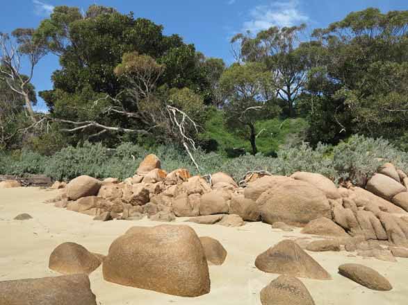
Towards the end of the beach at Cleeland Bight, where the dunes meet the Cape, there is an old granite quarry. The pink granite was formed in the Devonian period around 360 million years ago and in the 1890s was quarried by Chambers and Clutten for stone to face the Equitable Building on the corner of Collins and Elizabeth streets in Melbourne.
Today I have come at low tide to walk the trail through the dunes to Cleeland Bight and along the beach to visit the old granite quarry.
A road weaves through the dunes to the car park at Woolamai Beach. The rounded peaks and shallow hollows are covered in coastal shrubs, trees and grasses of dark green and silvery grey.
But the dunes weren’t always this way. When artist Jessie Trail and her sister visited the Woolamai dunes in 1929 she wrote: “We followed the shore, winding about the foot hills of pure sand as it were a desert”. Decades of grazing by cattle and rabbits had denuded the dunes that surveyor George Smythe described in 1842 as “open heathy land”.
Beside the road on the crest of the hill as Cape Woolamai comes into view, there is a remnant of the dune surface Jessie Trail would have seen. Bare sand is strewn with rhizoconcretions formed when sand cemented around the roots of shrubs and preserved them in enlarged gnarled shapes, now exposed by wind and rain.
The walking trail was first carved through the dunes in 1976, the same year a major revegetation program commenced. At this time the dunes were hills of spilling sand driven by onshore winds.
The restoration began with marram grass to trap the wind-blown sand. When the grasses took hold the soil conservation department workers and local volunteer planters followed with trees and shrubs. Thousands upon thousands of grasses, shrubs and trees were planted well into the 1990s.
The trail starts about 50 metres from the car park. A sandy path leads into a thicket of coast tea tree that opens to low sandy rises scattered with grasses and herbs.
I am soon among high dunes covered in a mosaic of coast banksia, coast wattle, coast daisy bush and coast beard heath.
Deeper into the dunes there are moist mossy nooks beneath the shrubbery and bower spinach and sea-berry saltbush ramble over fallen branches.
In spring, soft mauve orchids dance amongst delicate grasses and variable groundsels glow with bright yellow daisies.
A soft sound of the sea whispers through the trees and soon the path opens onto Cleeland Bight. The long sandy beach sweeps northward around to the San Remo bridge. To the south in the distance I can see pink rocks at the edge of the water with a low bluff rising up behind.
Smudges of fine black mineral sands sparkle on the surface of the beach nearby and a light breeze ruffles the calm water.
The wide body of water in front of me is the Eastern Passage, once an ancient river valley into which streams drained down from the Bass Hills and beyond, now the eastern entrance to Western Port. The river valley was drowned when the sea rose and surrounded Phillip Island, Churchill Island and French Island around 6000 years ago.
In the middle of the passage a lone fisherman appears as a small dot fishing from his tiny boat. Across the water, the village of San Remo rises gently to the Bass Coast cliffs which fade away to the south.
I turn and walk alongside the dunes towards the granite quarry. The first dune is very high and smooth. A sign obscured among some trees says “Fragile Dunes, No Sandboarding” but several children are screaming down the steep slope.
The dunes are now mainly stabilised but they will always remain fragile. Where dunes are eroding from above, the exposed roots of large shrubs dangle in the breeze. In places, sand has been sculptured into long low rows like miniature castle walls of a fortified mediaeval village. In others, loose sand spills down and fans onto the beach.
Some mature trees lie dead on the beach, ripped out by the longshore drift that moves northward along this shore.
The further I walk along, the more thickly vegetated the dunes become. Where mounds of loose sand remain, thick patches of hairy spinifex have gathered to stabilise the sand and new runners stretch out in trails like long slender fingers to hold the dunes in place.
The clumps of marram grass flourishing among the coastal shrubs are descendants of the original plantings all those decades ago. European marram grass was once widely used to stabilise dunes as it is easier to propagate than native hairy spinifex, but it is now considered a weed.
At the water’s edge, gentle wavelets have shaped deep ripples into the sand and a wide seagrass terrace with patches of sea lettuce has been exposed by the falling tide.
I reach a rocky outcrop of black basalt strewn with small boulders, cobbles and pebbles. From here I can see little sandy beaches across the water on the mainland at the base of the Bass Coast cliffs.
I continue past a bed of pink, white and purple seaweed and dark green seagrass stranded in a thick band above the shoreline and notice a solitary scallop shell resting on the sand.
I finally reach the end of the beach where the first sign of the old quarry is a neat line of large squared blocks of granite piled up to form a quay. In the 1890s this place was a bustling camp of around 50 men living in rough tents, quarrying the granite and loading it onto ships for transport to Melbourne. At low tide the granite blocks were moved by trolleys along a tramline and loaded onto a boat by jib-crane for sailing on the next high tide.
A pair of Pacific gulls are preening themselves on top of a smooth pink boulder in the water nearby while a pied cormorant swims around them, popping its head up now and then, appearing and disappearing in pursuit of fish.
Further on, several poles emerge from the water, presumably remnants of an old jetty, now a perch for cormorants.
I clamber over a huge jumble of cut and chiseled granite blocks left behind when the quarry was abandoned. They are covered with orange, black and lime-green lichen and splattered with guano. Some blocks have drill marks where steel wedges were driven in to split the stone apart.
The quarry is now overgrown with sea-berry saltbush and a grove of eucalypts skirted by silvery coast saltbush shrubs. A tiny path leads to some stairs where the roots of two Moreton Bay figs grip the side of the bluff.
I could climb the stairs and return to Woolamai Beach car park or continue on to the Beacon and The Pinnacles but today I prefer to return the way I came, along the beach beside the dunes and back across the sandy isthmus.
The old granite quarry has historic value for its part in the early European settlement of Melbourne and surrounding district. The Woolamai dunes have national geological significance for the way they tie mainland Phillip Island to Cape Woolamai. But perhaps the most vital part of this story is the restoration of a degraded landscape into a stable dune habitat for the native mammals, birds, reptiles and frogs that have made this place a home.
COMMENTS
August 2, 2016
Thanks Linda once again for your wonderfully descriptive and informative article about Cape Woolamai.
Jan Fleming, Cowes
The recent dunes piled into a sandy isthmus after the last phase of low sea level when wind-blown sand was whisked up from the sea floor, washed in by the rising sea then swept by winds from Woolamai Beach onto the old dunes.
Towards the end of the beach at Cleeland Bight, where the dunes meet the Cape, there is an old granite quarry. The pink granite was formed in the Devonian period around 360 million years ago and in the 1890s was quarried by Chambers and Clutten for stone to face the Equitable Building on the corner of Collins and Elizabeth streets in Melbourne.
Today I have come at low tide to walk the trail through the dunes to Cleeland Bight and along the beach to visit the old granite quarry.
A road weaves through the dunes to the car park at Woolamai Beach. The rounded peaks and shallow hollows are covered in coastal shrubs, trees and grasses of dark green and silvery grey.
But the dunes weren’t always this way. When artist Jessie Trail and her sister visited the Woolamai dunes in 1929 she wrote: “We followed the shore, winding about the foot hills of pure sand as it were a desert”. Decades of grazing by cattle and rabbits had denuded the dunes that surveyor George Smythe described in 1842 as “open heathy land”.
Beside the road on the crest of the hill as Cape Woolamai comes into view, there is a remnant of the dune surface Jessie Trail would have seen. Bare sand is strewn with rhizoconcretions formed when sand cemented around the roots of shrubs and preserved them in enlarged gnarled shapes, now exposed by wind and rain.
The walking trail was first carved through the dunes in 1976, the same year a major revegetation program commenced. At this time the dunes were hills of spilling sand driven by onshore winds.
The restoration began with marram grass to trap the wind-blown sand. When the grasses took hold the soil conservation department workers and local volunteer planters followed with trees and shrubs. Thousands upon thousands of grasses, shrubs and trees were planted well into the 1990s.
The trail starts about 50 metres from the car park. A sandy path leads into a thicket of coast tea tree that opens to low sandy rises scattered with grasses and herbs.
I am soon among high dunes covered in a mosaic of coast banksia, coast wattle, coast daisy bush and coast beard heath.
Deeper into the dunes there are moist mossy nooks beneath the shrubbery and bower spinach and sea-berry saltbush ramble over fallen branches.
In spring, soft mauve orchids dance amongst delicate grasses and variable groundsels glow with bright yellow daisies.
A soft sound of the sea whispers through the trees and soon the path opens onto Cleeland Bight. The long sandy beach sweeps northward around to the San Remo bridge. To the south in the distance I can see pink rocks at the edge of the water with a low bluff rising up behind.
Smudges of fine black mineral sands sparkle on the surface of the beach nearby and a light breeze ruffles the calm water.
The wide body of water in front of me is the Eastern Passage, once an ancient river valley into which streams drained down from the Bass Hills and beyond, now the eastern entrance to Western Port. The river valley was drowned when the sea rose and surrounded Phillip Island, Churchill Island and French Island around 6000 years ago.
In the middle of the passage a lone fisherman appears as a small dot fishing from his tiny boat. Across the water, the village of San Remo rises gently to the Bass Coast cliffs which fade away to the south.
I turn and walk alongside the dunes towards the granite quarry. The first dune is very high and smooth. A sign obscured among some trees says “Fragile Dunes, No Sandboarding” but several children are screaming down the steep slope.
The dunes are now mainly stabilised but they will always remain fragile. Where dunes are eroding from above, the exposed roots of large shrubs dangle in the breeze. In places, sand has been sculptured into long low rows like miniature castle walls of a fortified mediaeval village. In others, loose sand spills down and fans onto the beach.
Some mature trees lie dead on the beach, ripped out by the longshore drift that moves northward along this shore.
The further I walk along, the more thickly vegetated the dunes become. Where mounds of loose sand remain, thick patches of hairy spinifex have gathered to stabilise the sand and new runners stretch out in trails like long slender fingers to hold the dunes in place.
The clumps of marram grass flourishing among the coastal shrubs are descendants of the original plantings all those decades ago. European marram grass was once widely used to stabilise dunes as it is easier to propagate than native hairy spinifex, but it is now considered a weed.
At the water’s edge, gentle wavelets have shaped deep ripples into the sand and a wide seagrass terrace with patches of sea lettuce has been exposed by the falling tide.
I reach a rocky outcrop of black basalt strewn with small boulders, cobbles and pebbles. From here I can see little sandy beaches across the water on the mainland at the base of the Bass Coast cliffs.
I continue past a bed of pink, white and purple seaweed and dark green seagrass stranded in a thick band above the shoreline and notice a solitary scallop shell resting on the sand.
I finally reach the end of the beach where the first sign of the old quarry is a neat line of large squared blocks of granite piled up to form a quay. In the 1890s this place was a bustling camp of around 50 men living in rough tents, quarrying the granite and loading it onto ships for transport to Melbourne. At low tide the granite blocks were moved by trolleys along a tramline and loaded onto a boat by jib-crane for sailing on the next high tide.
A pair of Pacific gulls are preening themselves on top of a smooth pink boulder in the water nearby while a pied cormorant swims around them, popping its head up now and then, appearing and disappearing in pursuit of fish.
Further on, several poles emerge from the water, presumably remnants of an old jetty, now a perch for cormorants.
I clamber over a huge jumble of cut and chiseled granite blocks left behind when the quarry was abandoned. They are covered with orange, black and lime-green lichen and splattered with guano. Some blocks have drill marks where steel wedges were driven in to split the stone apart.
The quarry is now overgrown with sea-berry saltbush and a grove of eucalypts skirted by silvery coast saltbush shrubs. A tiny path leads to some stairs where the roots of two Moreton Bay figs grip the side of the bluff.
I could climb the stairs and return to Woolamai Beach car park or continue on to the Beacon and The Pinnacles but today I prefer to return the way I came, along the beach beside the dunes and back across the sandy isthmus.
The old granite quarry has historic value for its part in the early European settlement of Melbourne and surrounding district. The Woolamai dunes have national geological significance for the way they tie mainland Phillip Island to Cape Woolamai. But perhaps the most vital part of this story is the restoration of a degraded landscape into a stable dune habitat for the native mammals, birds, reptiles and frogs that have made this place a home.
COMMENTS
August 2, 2016
Thanks Linda once again for your wonderfully descriptive and informative article about Cape Woolamai.
Jan Fleming, Cowes