Big projects seem to be given priority over low-tech solutions to Phillip Island’s traffic woes, writes Mary Whelan, but we may be on the wrong track.
 The proposed Back Beach Road roundabout. Illustration: VicRoads
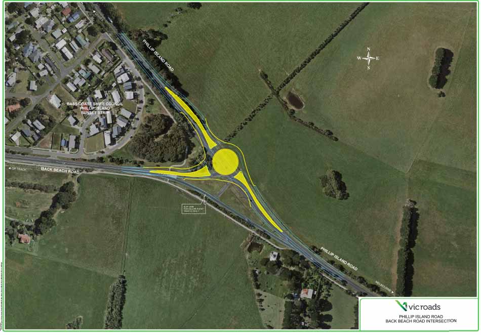
 By Mary Whelan
AS PHILLIP Island and San Remo grapple with rising populations of residents and visitors, our transport system is at a crossroads.
While VicRoads is proposing some very big engineering projects to improve traffic flow on the island, there is a concern that road and intersection upgrades will dominate the major funding for transport for the next several years.
Meanwhile, low-tech solutions are being overlooked, the community’s emphasis on safety seems to be forgotten, and there are no current plans to improve public transport services.
These are the solutions recommended by our community and adopted by the council in the Phillip Island Integrated Traffic Study (PIITS) in 2014.
How much do we build on the island to ease congestion? The community broadly accepts VicRoads plans for roundabouts at the Woolamai and Back Beach Road intersections with the main road. However, there is much less support for a proposal to widen the roundabout and road at Newhaven, and duplicate the Phillip Island Rd in the adjacent farmland along the Surf Beach, extending to the new roundabout planned for Back Beach Rd.
The council has adopted three different plans that express the community’s desire for alternatives to private car use on the island. These include improved public transport, works to encourage active transport (cycling and walking), a reduction in inappropriate speed limits to protect people and wildlife, and limits on visitor numbers at busy periods.
Background
PIITS encapsulated a community vision for integrating transport by:
Since then, the council has adopted two plans that have changed the transport landscape.
The Cowes Activity Centre Plan (adopted in March 2016) has four key priorities:
The Phillip Island Visitor Economy Strategy 2035 is committed to:
Progress
In 2014 a community reference group was set up to advise on priorities for action under PIITS and to inform the community of progress. Back then, our priority was safe access onto Phillip Island Road at the main intersections and through Surf Beach.
The State Government has now funded roundabouts for the Woolamai and Back Beach Road intersections and the authorities have accepted that Phillip Island Road needs upgrading at Surf Beach and San Remo to enable safe access. The ultimate design of these intersections is still the subject of community and council consultation with VicRoads.
The issue of congestion management has become highly charged. VicRoads data showing a traffic pinch point at the Newhaven roundabout led to a proposal to widen the roundabout and road to four lanes requiring an additional roundabout at Forest Avenue, with a service road in each direction to improve traffic flow. Many Newhaven residents and traders oppose the proposal.
VicRoads’ Surf Beach & Sunderland Bay Traffic Management Plan, which followed on from PIITS, outlined six options for improving safety and access, and through traffic. The final proposal was a dual carriageway bypass from Surf Beach to the Back Beach Road roundabout.
For many people this is an excessive amount of infrastructure given the community priority is safety, and the three relevant strategies place a very high value on the environment of Phillip Island.
The community has been told that it’s necessary to finalise the road design before starting other projects. But residents want to see progress on pathways, public transport and demand management.
The Pipeline Projects in the council’s capital works master list tell us that 32 pathways across the shire area have been authorised and have some funding allocated in this budget. Seventeen are on Phillip Island and San Remo.
The current budget allocated $827,500 across the shire for pathways. The total cost is estimated at $14,190,910. There is no time frame allocated to any of the projects listed.
Bass Coast’s Aspirational Network Pathways Plan, which was finalised in 2016, identified 53 aspirational paths that have not been built and were not on any work plans at that time.
Priorities
The priorities for 2019-20 should be to encourage active transport, as recommended in the Cowes Activity Centre Plan:
Cycle paths
The current bike path in Cowes is situated behind the existing angle parking bays, meaning vehicles back into cycle traffic. Moving the cycle path between the kerb and new parallel parking bays will improve cyclist safety.
Parallel parking bays make room for improved landscaping and greater pedestrian activity. Cyclists will be directed to turn right on Thompson at Chapel to link up with the new bikeway and footpath on Steele Street to head to the Esplanade.
Better bike paths and connections on Settlement Road will improve safety for school children.
Prioritising pedestrians
Replacing roundabouts with signalled intersections at the two major intersections on Thompson Road will improve safety for pedestrians and cyclists, especially school children. It also gets people out of cars and spending more money, which boosts the local economy.
Expanding public transport
We need more services from Cowes to Melbourne on weekends and more services across the Island. We also need better timetable information to include connections with local bus operators.
PIITS recommended:
As the first step in improving services, the community reference group asked the council to approach Transport for Victoria (TfV) to review our public transport. TfV declined. So there are currently no tangible actions in progress to make public transport a viable alternative to car travel.
Reducing speed limits
The Cowes Activity Centre Plan recommended reducing the speed limit to 40km/h in inner Cowes.
PIITS recommended:
VicRoads has acknowledged that the speed limit also needs to be reduced to 80 km/h on Phillip Island Road on the Melbourne side of the Silverwater Estate and Potters Hill Road, where there is poor visibility. No time frame has been set yet for this to occur.
Protecting wildlife
Our local wildlife carers have highlighted how many animals are injured and killed every week on Phillip Island’s roads. Two passionate, committed women who run a wildlife rescue service on Phillip Island keep statistics of wildlife kill hot spots where wildlife need extra protection. Phillip Island Nature Parks is also gathering data in order to recommend actions.
Road authorities need to change the ‘business as usual’ mindset of ensuring drivers get to their destination as fast as possible. They must lower official speed limits and install dynamic signage to further reduce speed limits in ‘hot spots’ at dawn and dusk.
In the current planning process for the Phillip Island Road Corridor, the PIITS community reference group, Landcare and PINP have all highlighted the need to consider wildlife and the major corridors of natural vegetation across the Island.
Reducing speed limits, overpasses and underpasses, escape routes, reducing roadside grass and water and public education to encourage fauna-friendly driving practices all need to be evaluated. Solutions should be based on local evidence and what is effective in other places of high environmental value.
Demand management
VicRoads rejected extended use of the Blue Line due to the work needed to widen and strengthen the road shoulders of Phillip Island Road.
Real time information
Early identification of likely high (non-event) demand is essential, with appropriate traffic management responses in place, including dynamic signage at Bass.
A local resident has developed a Facebook page which enables people to change their travel plans when traffic is at a standstill.
Mary Whelan is spokesperson for the community reference group advising on the implementation of the Phillip Island Integrated Traffic Study. This is an edited version of the group’s update to the community report for 2018.
AS PHILLIP Island and San Remo grapple with rising populations of residents and visitors, our transport system is at a crossroads.
While VicRoads is proposing some very big engineering projects to improve traffic flow on the island, there is a concern that road and intersection upgrades will dominate the major funding for transport for the next several years.
Meanwhile, low-tech solutions are being overlooked, the community’s emphasis on safety seems to be forgotten, and there are no current plans to improve public transport services.
These are the solutions recommended by our community and adopted by the council in the Phillip Island Integrated Traffic Study (PIITS) in 2014.
How much do we build on the island to ease congestion? The community broadly accepts VicRoads plans for roundabouts at the Woolamai and Back Beach Road intersections with the main road. However, there is much less support for a proposal to widen the roundabout and road at Newhaven, and duplicate the Phillip Island Rd in the adjacent farmland along the Surf Beach, extending to the new roundabout planned for Back Beach Rd.
The council has adopted three different plans that express the community’s desire for alternatives to private car use on the island. These include improved public transport, works to encourage active transport (cycling and walking), a reduction in inappropriate speed limits to protect people and wildlife, and limits on visitor numbers at busy periods.
Background
PIITS encapsulated a community vision for integrating transport by:
- providing alternate modes of transport to private car use,
- prioritising safety,
- protecting the characteristics that make the area attractive,
- improving and better utilising existing facilities to address congestion, and
- creating and protecting commercial opportunities.
Since then, the council has adopted two plans that have changed the transport landscape.
The Cowes Activity Centre Plan (adopted in March 2016) has four key priorities:
- Fixing the foreshore;
- Connecting the two ends of town;
- Recreating streets for people;
- Reinvigorating the character of Cowes.
The Phillip Island Visitor Economy Strategy 2035 is committed to:
- Sustainable growth
- Limiting visitor numbers to 24,500 visitors a day
- Encouraging investment in land for conservation
- Increasing native revegetation from 7% to 30% of island coverage.
Progress
In 2014 a community reference group was set up to advise on priorities for action under PIITS and to inform the community of progress. Back then, our priority was safe access onto Phillip Island Road at the main intersections and through Surf Beach.
The State Government has now funded roundabouts for the Woolamai and Back Beach Road intersections and the authorities have accepted that Phillip Island Road needs upgrading at Surf Beach and San Remo to enable safe access. The ultimate design of these intersections is still the subject of community and council consultation with VicRoads.
The issue of congestion management has become highly charged. VicRoads data showing a traffic pinch point at the Newhaven roundabout led to a proposal to widen the roundabout and road to four lanes requiring an additional roundabout at Forest Avenue, with a service road in each direction to improve traffic flow. Many Newhaven residents and traders oppose the proposal.
VicRoads’ Surf Beach & Sunderland Bay Traffic Management Plan, which followed on from PIITS, outlined six options for improving safety and access, and through traffic. The final proposal was a dual carriageway bypass from Surf Beach to the Back Beach Road roundabout.
For many people this is an excessive amount of infrastructure given the community priority is safety, and the three relevant strategies place a very high value on the environment of Phillip Island.
The community has been told that it’s necessary to finalise the road design before starting other projects. But residents want to see progress on pathways, public transport and demand management.
The Pipeline Projects in the council’s capital works master list tell us that 32 pathways across the shire area have been authorised and have some funding allocated in this budget. Seventeen are on Phillip Island and San Remo.
The current budget allocated $827,500 across the shire for pathways. The total cost is estimated at $14,190,910. There is no time frame allocated to any of the projects listed.
Bass Coast’s Aspirational Network Pathways Plan, which was finalised in 2016, identified 53 aspirational paths that have not been built and were not on any work plans at that time.
Priorities
The priorities for 2019-20 should be to encourage active transport, as recommended in the Cowes Activity Centre Plan:
Cycle paths
The current bike path in Cowes is situated behind the existing angle parking bays, meaning vehicles back into cycle traffic. Moving the cycle path between the kerb and new parallel parking bays will improve cyclist safety.
Parallel parking bays make room for improved landscaping and greater pedestrian activity. Cyclists will be directed to turn right on Thompson at Chapel to link up with the new bikeway and footpath on Steele Street to head to the Esplanade.
Better bike paths and connections on Settlement Road will improve safety for school children.
Prioritising pedestrians
Replacing roundabouts with signalled intersections at the two major intersections on Thompson Road will improve safety for pedestrians and cyclists, especially school children. It also gets people out of cars and spending more money, which boosts the local economy.
Expanding public transport
We need more services from Cowes to Melbourne on weekends and more services across the Island. We also need better timetable information to include connections with local bus operators.
PIITS recommended:
- Improving coverage of the existing network, so residents in townships are never further than 400 metres from a bus stop.
- Providing services at least half hourly.
- Running services from 6am-9pm on weekdays, 8am-9pm on Saturdays and 9am-9pm on Sundays.
- Developing facilities and routes that enable the highest number of people to use public transport services.
- Promoting development of Cowes- Anderson link and Phillip Island loop services.
As the first step in improving services, the community reference group asked the council to approach Transport for Victoria (TfV) to review our public transport. TfV declined. So there are currently no tangible actions in progress to make public transport a viable alternative to car travel.
Reducing speed limits
The Cowes Activity Centre Plan recommended reducing the speed limit to 40km/h in inner Cowes.
PIITS recommended:
- an 80 km/h limit on arterial and rural roads, which means reducing the 100 km/h limit on Rhyll-Newhaven Road, Back Beach Road after the race track, Ventnor Road to Grossard Point Road and Berrys Beach Road,
- 60 km/h on major and collector roads in urban areas;
- 40 km/h on residential and high pedestrian areas, including Surf Beach and Sunset Strip. It is pleasing to see action has been taken this year on the San Remo Access Strategy recommendation to reduce the speed in Marine parade to 40 km/h, improving safety for pedestrians.
VicRoads has acknowledged that the speed limit also needs to be reduced to 80 km/h on Phillip Island Road on the Melbourne side of the Silverwater Estate and Potters Hill Road, where there is poor visibility. No time frame has been set yet for this to occur.
Protecting wildlife
Our local wildlife carers have highlighted how many animals are injured and killed every week on Phillip Island’s roads. Two passionate, committed women who run a wildlife rescue service on Phillip Island keep statistics of wildlife kill hot spots where wildlife need extra protection. Phillip Island Nature Parks is also gathering data in order to recommend actions.
Road authorities need to change the ‘business as usual’ mindset of ensuring drivers get to their destination as fast as possible. They must lower official speed limits and install dynamic signage to further reduce speed limits in ‘hot spots’ at dawn and dusk.
In the current planning process for the Phillip Island Road Corridor, the PIITS community reference group, Landcare and PINP have all highlighted the need to consider wildlife and the major corridors of natural vegetation across the Island.
Reducing speed limits, overpasses and underpasses, escape routes, reducing roadside grass and water and public education to encourage fauna-friendly driving practices all need to be evaluated. Solutions should be based on local evidence and what is effective in other places of high environmental value.
Demand management
VicRoads rejected extended use of the Blue Line due to the work needed to widen and strengthen the road shoulders of Phillip Island Road.
Real time information
Early identification of likely high (non-event) demand is essential, with appropriate traffic management responses in place, including dynamic signage at Bass.
A local resident has developed a Facebook page which enables people to change their travel plans when traffic is at a standstill.
Mary Whelan is spokesperson for the community reference group advising on the implementation of the Phillip Island Integrated Traffic Study. This is an edited version of the group’s update to the community report for 2018.
 RSS Feed