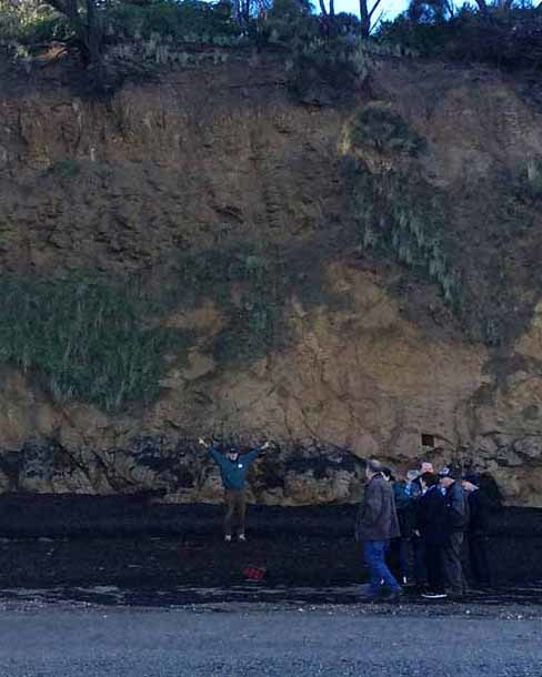
Mike Cleeland points out the dramatic rock formation of the infilled stream valley at Corinella. Photo: Meryl Brown Tobin
Volcanoes, gold, ‘pudding’ stones and more … last weekend’s information day on the Corinella foreshore was full of surprises.
By Meryl Brown Tobin
WHO would have expected to see evidence of ancient volcanic action along Corinella’s foreshore? The “Our Fascinating Foreshore” event at Corinella last Sunday, organised by the Corinella Foreshore Committee, proved more fascinating than many participants might have anticipated.
The morning’s first speaker, geologist Mike Cleeland, outlined the area’s volcanic background. Like Phillip Island which is 90 per cent volcanic lava, several areas of Corinella – specifically the Settlement Point area and back along the coast on either side and, on the southern side, stretching further to the southeast – show evidence of its violent geological past.
When a volcano erupts, liquid lava is thrown in the air. Lava solidified in mid air lands one or two kilometres from the centre of the volcano and is embedded in soft ash. Research done on Phillip Island and Mornington found the volcanic activity there occurred about 50 million years ago, and Mike expects the volcanic activity in Corinella to have occurred then too. This means dinosaurs weren’t around then as the rocks are too young. However, he didn’t rule out finding fossils of megafauna and other threatened mammals here in future.
On a beach walk west from the Beach Street steps, Mike pointed out cliffs of volcanic columnar structures in weathered basalt lava. Their height indicates the height of the lava flow which created them. Double and even triple layers of lava were exposed in some cliffs. Black pudding stones, hard lumps of basalt left as the surrounding rock became softened and weathered, stuck out of basalt lava.
“The black pebbles on the beach and buckshot gravel in the soil are iron oxide,” Mike said. “Groundwater brings iron ore up, evaporates and leaves the pebbles there.” He suspects that as the cliff erodes, the buckshot washes down, then wave action rounds small rocks, as it also does pieces of glass.
Participants readily identified brilliant examples of spheroidal or onion skin weathering where layers of rock are peeled off due to chemical weathering.
Mike also mentioned numerous shells at the bottom of the cliffs along the north shore. The lower level of shells are thought to represent the beach level around 2000 years ago, when global sea level was higher. The upper level of shells is probably an Aboriginal midden.
Mike pointed to bubbles in some of the rocks. “These are gas bubbles and they form in the liquid lava at the time of eruption, when the lava reaches the surface and the pressure is released, in a process similar to popping the cork on a bottle of champagne.”
One participant studied gas holes in the basalt at the water’s edge and noticed they were filled with green clay. Over time, and depending on what was in the groundwater, Mike said the gas bubbles could be infilled with gemstones, such as agate, as they had on Phillip Island.
The danger of rock falls was not lost on Mike. Once, when he and some Year 10 students were on a school excursion at Kilcunda, a rock the size of a piano fell off a cliff only 200 metres from them.
When asked what should be planted to slow or halt erosion, he replied, “It doesn’t matter because the rate of erosion is determined by the sea, not from above.”
Though the fall at Kilcunda was after a night of heavy rain and the mud holding rock could have been washed away, he said what was going on at the bottom of a cliff was more important. “The primary process is the undercutting of the cliff. To see how much a cliff erodes, he suggested nailing nails in a cliff and checking how much of them was exposed after successive months or years. “However, I don’t think Corinella is going to fall into the sea any time soon.”
Surprising to some was his saying that most of the sand on southern Victorian beaches is from the edge of the continental shelf to the south, and it has come in with the rising sea since the last glacial maximum some 20,000 years ago.
Mangroves were also mentioned. “As sea levels are rising, mangroves are moving inland, for instance, up drainage channels at Koo Wee Rup.” He said the options re climate change, rising sea levels and eroding coastlines were to do nothing; plant mangroves; erect floating off-shores barriers or build rock walls. To build rock walls, the most expensive option, was unfeasible, due to the cost.
For those wanting to learn more about Corinella’s geology, Mike recommended the Victorian Geology Excursion Guide which includes 4-5 pages on Corinella and to google ‘Sites of Geological and Geomorphical Significance’ or Victorian Resources Online Corinella.
Though Mike showed those who walked with him where to look for gold in an infilled valley exposed in the cliffs, he stressed, “If anyone finds gold, I want my cut.”
The second speaker, Alison Oates, a botanist and environmental consultant, discussed landscapes of Corinella and ecological vegetation classes (EVCs). Alison helped prepare EVC maps and models of pre-1750 distribution of vegetation communities. To work out what was present prior to European settlement, she researched historical maps and reports, early surveyors’ maps and parish plans, historical paintings and photos, remnant vegetation on roadsides and remnant trees in paddocks. She considered erosion was accelerated by the increase in groundwater.
In the afternoon Alison walked a group along Cuthbert Street to the foreshore and along to O’Connor Road to study plants of the reserve. Then they accessed the beach via the steps there and walked up to the Beach Street steps. Coincidentally, they met up with Mike’s group and compared notes and wet feet as the tide was coming in by then.
The third speaker was Peter Merritt, a senior environmental planner with the Department of Environment, Land, Water and Planning (DELWP). Peter spoke on management of the foreshore reserve and obligations under the RAMSAR Agreement to protect wetlands. “Where possible, we avoid loss of vegetation; put forward proposals to minimise it, offset it with replantings elsewhere; and/or revegetate the area.”
Because of the RAMSAR Agreement, upgrades for the boat ramp must be referred to the relevant federal government department.
When a questioner wanted to discuss the effects of horses, rabbits, birds from Alaska and developers on the foreshore, Peter Merritt said, “It is a challenge when you have often conflicting aims. So many groups want to visit.”
To go on the committee, you need to be passionate about the country you live in, Peter said.
The fourth speaker was educator and illustrator Nic Day, the artist of Simpson and Day’s Field Guide to the Birds of Australia, which has sold over half a million copies. Nic showed photos of local garden and bush birds including white-eared honeyeaters, superb fairy wrens, king parrots, rainbow lorikeets, common bronzewing pigeons, noisy miners, little wattlebirds and white-bellied sea eagles. However, threats to bushland habitat can lead to their demise, he said. For instance, around 10 years ago in the Tenby Point area, tree martins suffered when huge numbers of trees were cut down and burnt.
Nic said dogs could be another threat to birdlife. “I gave up taking my dog on the beach 15 years ago – there are other places to exercise them.” He is especially concerned about dogs on beaches in the warmer months and especially on surf beaches where hooded plovers nest. “A hooded plover nest looks like a heel print.”
Unlike some naturalists, Nic Day believes in the supplementary feeding of birds to help offset human activity.
Later he led a walk from Balcombe St to the jetty to study the shorebirds of Corinella. At this time of the year, many swans congregate and feed in the mudflats alongside the coastal walking track and in the sea.
Apart from the excellent talks and walks, the 70 or so participants enjoyed a superb lunch of soup, sandwiches, pizza, party pies and sausage rolls, quiche and cakes, thanks to the ladies of St George’s Anglican Church, Corinella.
Many thanks also to MC Michael Johnson, chair of the Corinella Foreshore Committee, and to the committee for hosting the day, the brainchild of Barb Oates, and to the knowledgeable and entertaining speakers.
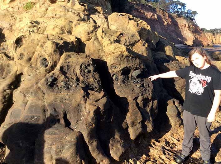
Wave, one of the younger participants on Sunday, points out “pudding stones” in the basalt lava. These are hard lumps of basalt that have been left as the surrounding rock becomes softened and weathered. Photo: Mike Cleeland
COMMENTS
June 26, 2017
Another excellent edition - thanks!
Meryl’s article was great. I was fascinated to learn of the Corinella volcanics - not an area I know well.
Mike: Is this another dot point in your prescription for action on climate change?
What if we re-created as many swamps as we could in the footprint of the ancient Kooweerup Swamp, using the water for local irrigation, recreation and biodiversity, and somehow letting as little as possible flow directly into Westernport Bay?
Rob Youl