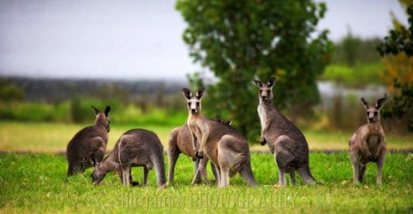
The Gurdies residents have the privilege of watching roos graze at dusk and dawn. Photo: Elizabeth Richardson
Residents of The Gurdies opposed to a rezoning of their land for tourism are advocating not just for their own futures but for the lives of all the creatures who live around them.
By Liz McDonald
WE AT The Gurdies are feeling overlooked.
Not all of us, or Bass Coast Post readers, have read the hefty Rural Land Use Strategy documents. But within the massive detail of the Rural Land Use Strategywhich covers the whole of Bass is a proposal to rezone parts of The Gurdies from Farming to Rural Activity.
The proposed Rural Activity Zone (RAZ) at The Gurdies is split into two sections, a triangle on the Bass Highway on the corner of St Helier Road, known locally as Fantasia, and the adjoining property, and the farming properties further up the hill round to the gravel Dunbabbin Road, which is the southern entry to The Gurdies Nature Conservation Reserve. The proposed rezoning affects fewer than 20 households/owners who received some documents in early October last year; the other 70 or so households sandwiched between these two sections in residential areas were not consulted.
Seven of the affected households sent letters to the strategy planners (who we gather had a total of 10 objectors), not a bad response for 20 households. Seven of us were pleased to be able to table questions to the council at last Wednesday's meeting. Our questions were answered by referring us to the very documents that had caused our initial concerns. And we have each done hours of research and reading.
It is hard when there are so few of us to have a voice. So I'm pressed to write to the Bass Coast Post to air some of our concerns.
Our land at the top end of The Gurdies-St Helier Road is wedged between The Gurdies and the Hurdy Gurdy Creek Nature Conservation Reserves. Most of the larger properties abut one of these reserves, and the smaller holdings have the privilege of watching the roos graze at dusk and dawn or seeing them pass through.
This section of The Gurdies is recognised as a wildlife corridor – from The Gurdies NCR to Hurdy Gurdy Creek NCR to the Peacock Road reserve to the GMH proving ground. Or it was recognised. For I have not seen any mention of this important fact in the documents about the proposed Gurdies RAZ.
I'm told that surveys have been done in the past of this animal traffic, but we see evidence of it each evening, night and morning, some of it, alas, as carcases on the road.
These two reserves were set aside for their “valuable examples of foothill forest, sandy heathland and swamp scrub”, for their “riparian forest and coastal grassy forest”. They house, I'm told, 18 species of mammals, 130 species of birds, 15 reptile species and 340 identified plants, including 54 types of orchids.
A Rural Activity Zone is intended “to support rural based tourism” and, yes, there are some important strictures placed on what this means. But what may or may not be included in “tourism activities” seems open-ended to us. What we do know is that rules can be, and probably will be, broken in the future when all this is forgotten and the council personnel change. We are advocating not just for our future but for the lives of all those creatures who live around us.
It seems that the very idea of a RAZ injected into our peaceful hillside is exactly counter to council policy of protecting and enhancing environmental values.
COMMENTS
February 25, 2016
Bravo, Liz McDonald for expressing so eloquently what conservationists and other lovers of nature and all who appreciate the sustainability of our natural environment have been saying for years!
The biggest issue we see in the Bass Coast Shire is the need for a sustainable environment and Liz McDonald’s desire to protect The Gurdies bush is part of satisfying this need.
To quote the council’s own Environmental Sustainability Plan 2008-13, p14: "One of the most critical local environmental issues for Bass Coast is that there is less than 10% of indigenous bush remaining from pre 1700s. There is research and a common acceptance that if there is 35% cover of native vegetation then 75-80% of species can survive, but below that level extinctions can accelerate rapidly."
In 1996 nearly 1139 people signed a petition for the creation of a Westernport Bay National Park which would incorporate the Hurdy Gurdy Creek, The Gurdies and Grantville Nature Conservation Reserves and other Crown Land, including the coastal strip between the mouths of the Bass and Lang Lang Rivers (See attached clipping).
Although these people had the vision to see that, to retain our wildlife, we have to ensure they have land and wildlife corridors to operate in, our council and State Government of the time did not have similar vision.
So, 20 years later, we still must fight the same battles. Where are our councillors and council staff ready to stand with these 1139 petitioners, and no doubt many more with similar views now? Which of them will support, in the short terms, all areas of remnant vegetation being declared Rural Conservation Zones and not being allowed to become Rural Activity Zones?
Then, if protected now, these bush areas, in the long term, could still become part of the bigger vision, the Westernport National Park.
Meryl Tobin, Grantville
February 21, 2016
Thanks for your article, Liz. It demonstrates how hard it is for individuals to be heard and understood when they stand in the path of a bureaucratic juggernaut.
Good luck to you and your small band as you strive to protect an environment we love.
Gill Heal, Jeetho West