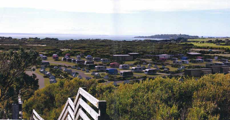
An artist’s montage of a proposed caravan park at Forrest Caves.
By Phil Wright
ON MONDAY the Victorian Civil and Administrative Tribunal will begin hearing arguments in favour of a 208-site caravan park backing on to the Forrest Caves beach reserve on Phillip Island.
The appellants are appealing against a decision by Bass Coast councillors in September 2017 to reject their proposal. (See Caravan park knocked back.)
When VCAT decides whether to reverse council’s decision, it must consider the risks and the benefits to the community. In my opinion, there are very little benefits to the proposal but there are very serious risks. Apart from the obvious risks to one of the island’s best natural beaches, there is the bigger issue of precedent.
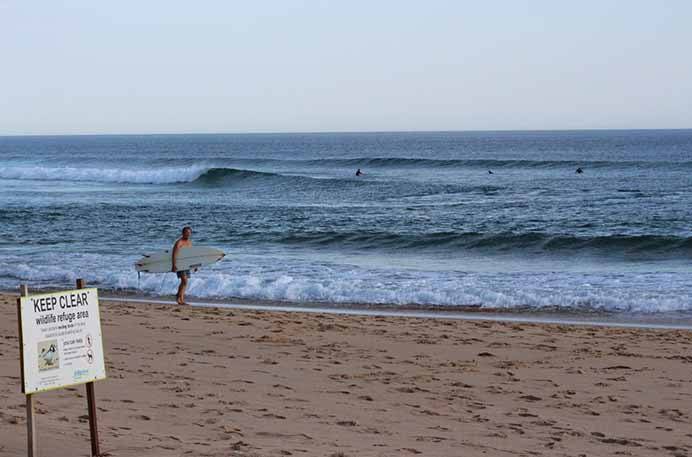 Forrest Caves beach, where surfers share the waves with threatened species.
 ‘The environment is the economy’
The introduction to the Phillip Island Visitor Economy Strategy, written by Bass Coast’s mayor of the day, stated “The environment is the economy.” Few would disagree.
The problem with current planning controls on Phillip Island is that the environment is being diminished gradually by private owners and operators with the mantra “The environment is the foundation of my business plan”.
While small compromises have little impact, all the negative impacts joined together create a large compromise to the natural environment.
A history in four quarters
It’s telling to look at a history of Phillip Island’s rural land use.
Quarter 1: Disastrous width of coastal reserves
The earliest survey plan of the island was published in 1887. The surveyors of the day were instructed that the island was high quality farming land and the coastal reserve must be 30 metres from high tide. How beautiful the island would be if they had restricted private land ownership to 200m from the high tide mark.
Quarter 2: Disastrous sub-division of coastal areas
In the 1950s the Shire of Phillip Island released numerous estates for holiday homes. They had no water, sewerage, drainage or constructed roads. Worse – they had no public open space. The developers were permitted to subdivide every square metre for profit.
Quarter 3: Growing awareness in the 1970s
Then Liberal Premier Dick Hamer realised the value of the island for the people of Victoria and introduced a Bill into Parliament to protect wildlife and vegetation and enable compulsory acquisition of significant sites. It included a toll on the bridge with funds to be used for environmental protection and land purchase. For various reasons, the bill was never enacted.
Quarter 4: Oh no, not the Rural Land Use Strategy (RLUS)
Bass Coast’s RLUS was a process in which three years was spent arguing whether farmers could build a second house on their land. It considered that all rural land should be used for primary production. This is a shallow and simplistic conclusion.
The Gippsland Growth Strategy has Phillip Island listed as landscapes and active recreation, not primary production. Australia’s supermarket duopoly makes it almost impossible for small farmers to survive. Needless to say their children are running away in droves.
This land’s too valuable to farm it
Of all areas outside Melbourne growth area, Phillip Island has some of the most valuable land in Australia. Every acre needs to be used for the best community benefit. Rural properties should be used for three main activities:
This could come about by the introduction of a tourism transition zone where rural landowners can choose whether to remain zoned for farming or be rezoned “Tourism Transition”.
The consistent wearing down of the very weak rural land use strategy is inevitable: Cape Kitchen, Pattons Shed, the proposed Caves caravan park and now the Gap Road proposal. I want to be out in front having a plan that leads to the whole of the island becoming a national park.
We are struggling to hold back the onslaught. Let’s use the Phillip Island Bill (1970) and Brown Bible to define what is best for Victoria rather than fighting off inappropriate proposals.
Phil Wright is a surfer and former councillor of both Phillip island Shire and Bass Coast Shire.
The introduction to the Phillip Island Visitor Economy Strategy, written by Bass Coast’s mayor of the day, stated “The environment is the economy.” Few would disagree.
The problem with current planning controls on Phillip Island is that the environment is being diminished gradually by private owners and operators with the mantra “The environment is the foundation of my business plan”.
While small compromises have little impact, all the negative impacts joined together create a large compromise to the natural environment.
A history in four quarters
It’s telling to look at a history of Phillip Island’s rural land use.
Quarter 1: Disastrous width of coastal reserves
The earliest survey plan of the island was published in 1887. The surveyors of the day were instructed that the island was high quality farming land and the coastal reserve must be 30 metres from high tide. How beautiful the island would be if they had restricted private land ownership to 200m from the high tide mark.
Quarter 2: Disastrous sub-division of coastal areas
In the 1950s the Shire of Phillip Island released numerous estates for holiday homes. They had no water, sewerage, drainage or constructed roads. Worse – they had no public open space. The developers were permitted to subdivide every square metre for profit.
Quarter 3: Growing awareness in the 1970s
Then Liberal Premier Dick Hamer realised the value of the island for the people of Victoria and introduced a Bill into Parliament to protect wildlife and vegetation and enable compulsory acquisition of significant sites. It included a toll on the bridge with funds to be used for environmental protection and land purchase. For various reasons, the bill was never enacted.
Quarter 4: Oh no, not the Rural Land Use Strategy (RLUS)
Bass Coast’s RLUS was a process in which three years was spent arguing whether farmers could build a second house on their land. It considered that all rural land should be used for primary production. This is a shallow and simplistic conclusion.
The Gippsland Growth Strategy has Phillip Island listed as landscapes and active recreation, not primary production. Australia’s supermarket duopoly makes it almost impossible for small farmers to survive. Needless to say their children are running away in droves.
This land’s too valuable to farm it
Of all areas outside Melbourne growth area, Phillip Island has some of the most valuable land in Australia. Every acre needs to be used for the best community benefit. Rural properties should be used for three main activities:
- Primary production – gives visitors the feeling of connection to food chain and openness of rural land (50%)
- Revegetation (40%)
- Tourism activity – caravan parks, luxury cabins, yoga camps, jazz clubs, gay clubs, dogs off leash areas, natural cemeteries, horse riding areas, restaurants,
This could come about by the introduction of a tourism transition zone where rural landowners can choose whether to remain zoned for farming or be rezoned “Tourism Transition”.
The consistent wearing down of the very weak rural land use strategy is inevitable: Cape Kitchen, Pattons Shed, the proposed Caves caravan park and now the Gap Road proposal. I want to be out in front having a plan that leads to the whole of the island becoming a national park.
We are struggling to hold back the onslaught. Let’s use the Phillip Island Bill (1970) and Brown Bible to define what is best for Victoria rather than fighting off inappropriate proposals.
Phil Wright is a surfer and former councillor of both Phillip island Shire and Bass Coast Shire.