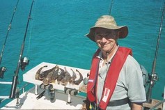
Kevin Chambers has fished on Western Port for more than 60 years. He wonders how much longer the bay will be a fisherman’s paradise.
By Kevin Chambers
MY PARENTS established our first holiday home at San Remo in the early 1950s, and soon afterwards my mum, Florence (Fofo) Chambers, taught me how to catch “leatheries” off San Remo pier.
I’ve holidayed/lived/fished in and around Western Port Bay ever since. I’ve been a member at Newhaven Yacht Squadron since I bought my first boat in 1980. I’m now on my third, and last, “tinny” and launch from either the Squadron ramp or at Corinella.
Now, given the plan to expand the Hastings port into one of the biggest container ports in Australia, I fear for the future of “my bay”.
The proposal continues to attract a lot of claims, some of them accurate, some of them not so accurate. A prime example of the latter is claims about the amount of dredging required to make it all work and the impact of that dredging on the bay.
What is not widely known is that the July 2011 edition of Parks Victoria’s Western Port Recreational Boating Guide has at least 40 per cent of the safe, high tide navigable waters of Western Port marked as “Hastings Port Limit”. Earlier editions of this publication did not indicate this. The marked area starts out past the Nobbies, widens out the existing shipping channel by at least 70-80 per cent and continues in this vein right up to the proposed container port site north of Long Island Point.
There’s even a small section in the first couple of kilometres in the Middle Spit Channel, heading north from Tankerton. Tugboat resting ground, perhaps? It’s too small for anything else.
Given the shallow nature of the bay directly out from the container port site, and the requirement to dredge a swinging basin down to 14 metres at this location, why does the port limit stop west of the channel into Watsons Inlet, when clearly, given the length and draft of the ships proposed to use the port, much more area is required for the swinging basin? This is exemplified by the Cowes/Rhyll area being almost twice the size of that off Hastings. Surely for the sake of marine safety, they need to be roughly the same size.
The rectangular eastern arm extends from Red Rocks to just north of Rhyll and covers the entire bay area from the north coast of Phillip Island right up to adjacent Tortoise Head Bank
It is necessary to zoom in quite a bit to pick up the expanded port limits, but they are there in their entirety.
If this is declared a prohibited anchoring area, what does it mean for recreational fishing in Western Port? The yachties may be able to safely transit through it, but with anything up to three 400-metre-long, 60,000-tonners anchored/manoeuvring in such a small space, I wish you all the best, especially if it’s a bit rough and there’s a spring tide running against the wind. Or conversely, no wind and you have to start your engine to get out of the way of one of these monsters.
Wiping out almost half of the fishable half of the bay would put intolerable pressure on the remaining sections, not only on the water, but on land. The current snapper season queues on the ramps would be a picnic in the park by comparison. On cup weekend, the queue to get on and off at Corinella was 400 metres long and the fishos were taking two hours to get their boats in or out.
I’m not sure how you’d run a yacht race out there, either, not with the dramatically increased number of fishing boats either anchored or under way.
If the new container port is built and the new Port limit is not designed to restrict recreational boating, why have it there in the first place.
Port Phillip currently handles about 3000 ships a year, or in ship movements, 16 a day, (eight in, eight out). Roughly the same is predicted for Hastings. At low tide Western Port has quarter of the surface area of Port Phillip. It begs the question of where the Port Authority is going to fit them all. Unless, of course, they dredge the bay to death, as is feared.
Kevin Chambers is a founding member of Preserve Western Port, an action group campaigning against the expansion of the Port of Hastings.
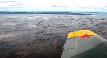
An aerial photo of Western Port at low tide shows how shallow much of the bay is. Photo: Kevin Chambers