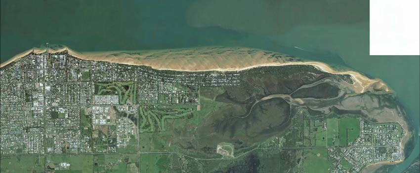
An aerial photo shows how Cowes (left), Silverleaves (centre) and Rhyll (right) are buffered by sand banks and mudflats. Photo: Bass Coast Shire Council
By Jeff Nottle
THE tides of Western Port define our ecosystem, beaches and land mass. Western Port has a unique structure of deep water, shallow water and mudflats that all form part of our environment.
The tides in Western Port are unique, running at speeds not seen in many other places.
Battle lines drawn in port campaign
Tides at the western entrance near the Nobbies average around 2 knots and the tides at the eastern entrance at Newhaven and San Remo average around 5-6 knots (9-11kph). The tides and water flow at Newhaven are sufficient to operate a current turbine that produces electricity for our grid.
Twice a day, vast amounts of water enter Western Port through the western entrance, producing spring tides that ebb and flow up to three meters in height.
With a south-westerly blowing and swells from Bass Strait, combined with sections of deep water, the incoming tide moves huge volumes of water into Western Port that dissipate on the middle bank and Tortoise Head. This area is located north of Cowes and Silverwater and adjacent to French Island.The water then flows north towards Hastings and travels in a clockwise direction around French Island.
As the tide flows and rises around French Island, more than 100 square kilometres of mud flats are flooded. At high tide the water starts to ebb and the water flows past Grantville, Corinella and Coronet Bay and speeds up on its way to Newhaven and San Remo.
The proposed expansion of the Port of Hastings will necessitate a huge amount of dredging to enable the projected number of container ships to use the port. The current shipping channel to Hastings will need to be widened and deepened. Large areas will need to be dredged at the port itself to allow these huge ships to swing around. Anchorage for the ships has been identified in the declared waters north of Cowes and Silverleaves.
Dredging will remove vast amounts of sea bed and remove existing obstacles in the water such as under water rocks and mud flats that currently tame the flow of the water as well as provide extremely important habitat.
Increasing the volume of water entering Western Port combined with the removal of naturally occurring obstacles means the water will flow at an ever-increasing rate.
Land reclamation in the north of Western Port, new container port infrastructure at Hastings and increased tidal flows will combine to create a “fire hose effect” as the incoming tide flows around French Island, shifting huge amounts of sand and mud that will affect the mud flats and the coast.
During the ebb tide there will also be increased tidal flows and an increase in water volume directed at the north shore of Phillip Island, directly off Cowes.
Bass Coast Shire Council has recently identified areas in Cowes and Silverleaves at risk of inundation. The increase in water flows and speed of the tide will place this fragile and unprotected area at even greater risk.
It may take years to see and understand the final effects of dredging for the Port of Hastings. What is clear is that dredging Western Port will change our coast, environment, beaches, recreation and land mass.
The Port of Hastings evaluation process needs to address the changed tidal impact on Phillip Island and the communities of Western Port, as does the council’s own economic impact analysis.
Jeff Nottle is chairman of Preserve Western Port, a new action group campaigning against the development of the Port of Hastings. He was formerly the acting co-ordinator of strategic planning for Bass Coast Shire.