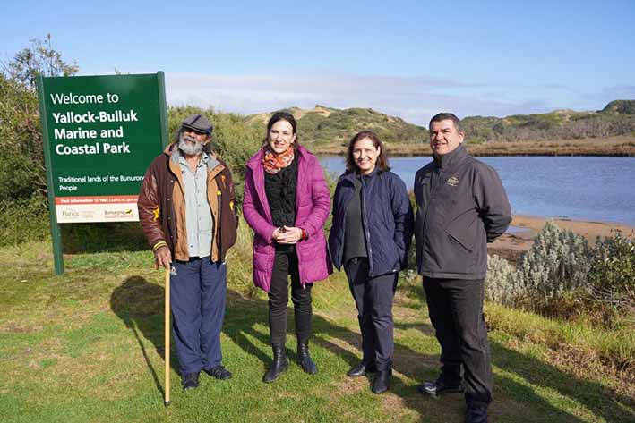
 Victoria’s newest park, the Yallock-Bulluk Marine and Coastal Park, was officially launched on Sunday at the Mouth of the Powlett.
 From left, Bunurong Land Council chairman Uncle Mik Edwards,
Bass MP Jordan Crugnale, Environment Minister Lily D’Ambrosio and
Parks Victoria chairman John Pandazopoulos.
By Leticia Laing
LAST Sunday Environment Minister Lily D’Ambrosio officially launched the Yallock-Bulluk Marine and Coastal Park at the Mouth of the Powlett.
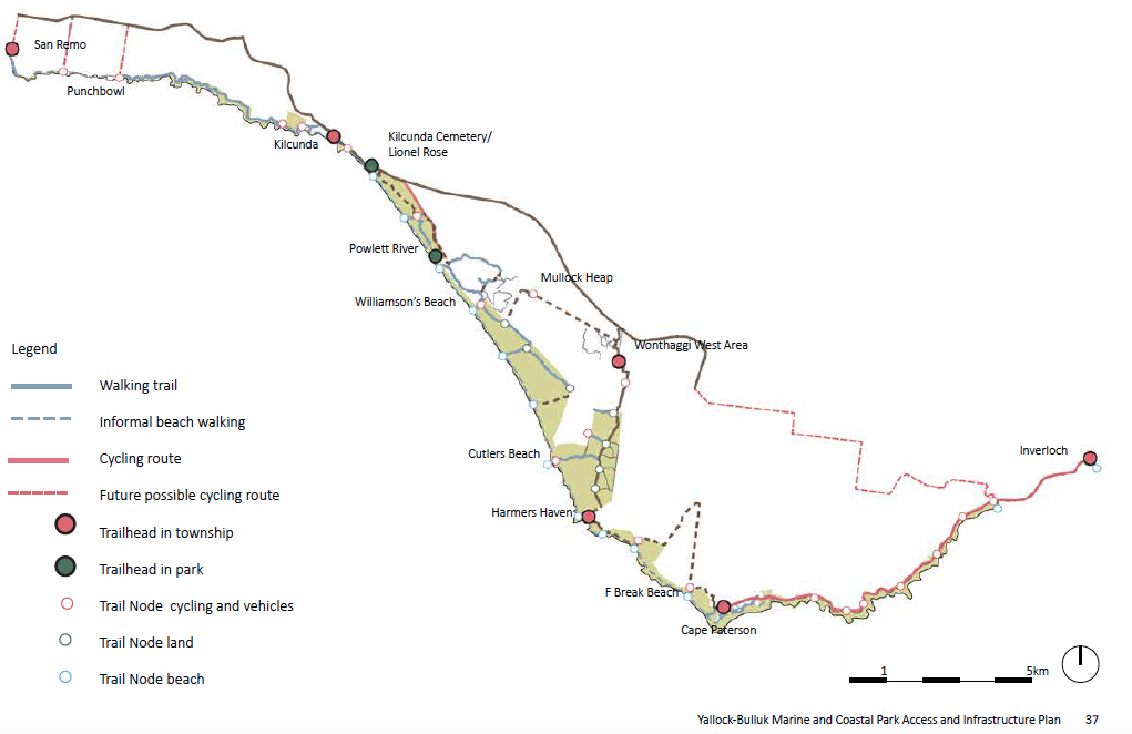
The goal of connecting 40km of walking and cycling trails from San Remo to Inverloch is a lofty one and in some ways unrealistic when viewed in the context of the fragility of the environment and the many hazardous elements to this coast.
LAST Sunday Environment Minister Lily D’Ambrosio officially launched the Yallock-Bulluk Marine and Coastal Park at the Mouth of the Powlett.
The goal of connecting 40km of walking and cycling trails from San Remo to Inverloch is a lofty one and in some ways unrealistic when viewed in the context of the fragility of the environment and the many hazardous elements to this coast.
I was curious to see how the designers would address the many complexities of navigating a walking trail through this part of the Bass Coast.
 Land in private ownership currently prevents the public from enjoying a large portion of the
 San Remo coastline.
The path suggests a welcome deviation through Wonthaggi Heathland, potential for access to the State Coal Mine and better acknowledgement of Aboriginal cultural sites and spaces as well as potential for inland routes.
Stage 2 of consultation saw the release of a draft infrastructure plan that was widely criticised by parts of the community.
The idea of about 60,000 visitors tramping along the coastline, as David Arnault described in his article Yes I’m a Nimby! is not comforting to the thousands of locals who have spent decades revegetating and protecting it.
Yet I've always been of the mind that special areas can be managed and protected using a variety of tools.
In the mid 1980s the State Government acquired the Summerlands Estate to protect the penguin colony. This visionary step led to the development of the Phillip Island Nature Park: the growth of a multi-million dollar tourist economy and numerous initiatives to protect Phillip Island which is now even fox free and home to the endangered eastern barred bandicoot.
It is expected that about $10m of the $19.6m allocated for the new park will go into land acquisition, hopefully to acquire some in San Remo to avoid the enormous detours walkers would have to do under the current plans.
However, the consultation process did little to allay the fears of locals that this was a metro-driven project.
According to the Harmers Haven Residents and Ratepayers Association’s second submission to the YBMCP plans, there were incorrectly drawn trails and suggestions for swimming at dangerous beaches. For example, the maps pointing to recreational swimming at Wreck Bay Beach or even Cutler’s Beach had no caveats to warn people about the strong rips present at these beaches.
It’s not a deal-breaker to suggest swimming at a dangerous beach - Wilson’s Promontory has numerous splendid, unpatrolled and dangerous beaches that can be accessed for swimming.
Nor did the Yallock-Bulluk draft plans address the problem of protecting hooded plover nesting sites while at the same time making these sites primary beach walking areas.
Then, as the trail makes its way from Cape Paterson to Inverloch, it goes on to make the bizarre suggestion of making the Cape Paterson-Inverloch Road a one-way road with the other lane allocated to cyclists and walkers.
Designers went to great lengths to suggest a “key move” would be a one-way road between
Inverloch and Cape Paterson.
Inverloch and Cape Paterson.
Once the maps were released, Bass MP Jordan Crugnale reassured the community that all options would be on the table and the one-way was merely a suggestion. But it begs the question, how did this suggestion even get on the table? Did the planners consider that hundreds of people living in Cape Paterson like to go to Inverloch and return home without a 20km detour? Or vice versa?
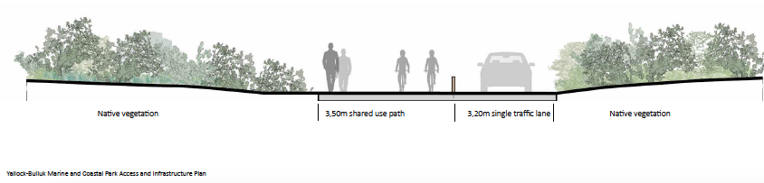
For years the community has desired a safe cycling and walking path along this road. Granted, the extensive verge vegetation poses a significant challenge, especially as the track crosses deep gullies and precariously borders the cliffs.
Historically this road was more of a goat track, but it is now the main route between Cape Paterson and Inverloch and, arguably, the jewel in the scenic route crown of the Bass Coast that, in this modern day, should be accessible to more than motorists.
There were no other proposals for a cycling route along this road in the draft plan and the possibility of a path on the opposite side of the verge vegetation (on the farm side of the road) was not explored.
Making the path accessible to a range of people, some who may not be able bodied, isn't necessarily a bad thing - if it's done properly. Restricting access usually means only physically and monetarily privileged individuals gain the opportunity to view these special places when it should be something everyone can see, appreciate and love.
There's also the argument that if people don't experience the beauty of this space they won’t appreciate it or protect it.
Bass Coast is the second most tourism-dependent shire in Australia, after Uluru. To think otherwise is a misconception of our isolation. Annually the shire’s population swells to about 70,000 people in peak season.
COVID has decimated international tourism the Penguin Parade was reliant upon, but there are still many who want to enjoy what else Bass Coast can offer.
Many have chosen to retire here in peace but quite a few who live here make the coffees, wait on tables and eke out a living on the ungenerous wages that hospitality serves.
Population projections suggest the demographic is changing as Melbourne property prices become too far out of reach for lower-middle income earners.
Our beautiful spaces need better management. Creating a mostly connected nature trail is essential to prevent neglect or damage by individuals forging their own way without consideration of the fragility of the environment.
So far the process has not been entirely reassuring that it will address the eco-concerns or that it will be creative and courageous about areas begging for improvement.
Most notably, however, this park design will not be the final iteration of the Yallock-Bulluk Marine and Coastal Park.
This funding will set the stage for further development and growth of a nature park and camping grounds - just as the Penguin Parade started with a few rope cordons along a beach all those years ago.
Protecting these areas shouldn't be pitched in economic terms. You really can't quantify that feeling you get standing on the edge of the world, watching some breaching whales go by ...
The views expressed here are those of Cr Leticia Laing and not Bass Coast Shire Council.
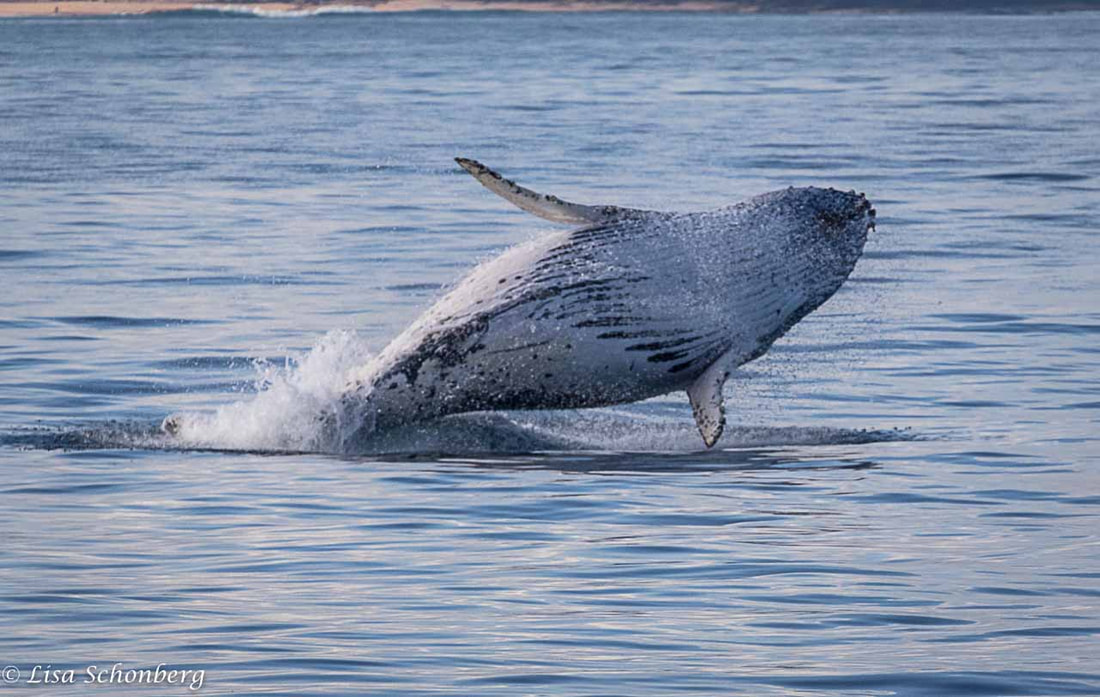
Photo: Lisa Schonberg