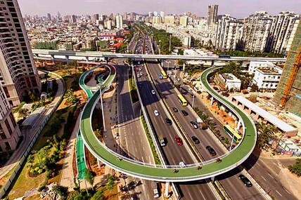
 Bicycle path over highway overpass, Fujian province, China
 What do we want Phillip Island to be like in 50 years? Phil Wright reckons the Distinctive Areas and Landscapes project enables us to think big.
By Phil Wright
THE vision shown by the council in allocating funding for both the Smiths Beach Master Plan and Distinctive Areas implementation is greatly appreciated.
As a community we’re now obligated to let the creative juices flow. What do we want the shire, and in particular Phillip Island, to be like in 50 years? Our future is an empty page that we are encouraged to write on.
The history of Phillip Island is a legacy of poor decisions that responsible land managers must work around at later decades:
Existing strategies
The Visitor Economy Strategy states that the island can only cope with 25,000 daily visitors. This number is not explained but it is a good starting point. We must also introduce a way for visitors to contribute towards construction and maintenance of key infrastructure.
The viability of local businesses is complicated by the seasonal variation in visitor numbers. Anything we can do to encourage visitors during winter should be considered. The north-east of the island is a separate microclimate, protected from southwest winds by the ridge that runs through the middle of the island.
The entire area east of Thompson Avenue could become a magnificent recreational area for families to walk, ride and enjoy the tall blue gums and other natural assets of Western Port, the Rhyll wetlands, Conservation Point, Silverleaves and the Oswin Roberts Reserve.
Traffic flow
All discussions about traffic flow on the island start with the current San Remo-Cowes corridor through Five Ways, with all its problems:
THE vision shown by the council in allocating funding for both the Smiths Beach Master Plan and Distinctive Areas implementation is greatly appreciated.
As a community we’re now obligated to let the creative juices flow. What do we want the shire, and in particular Phillip Island, to be like in 50 years? Our future is an empty page that we are encouraged to write on.
The history of Phillip Island is a legacy of poor decisions that responsible land managers must work around at later decades:
- Only allowing 30 metres from high tide for a costal reserve when the island was first subdivided.
- Approval of numerous sub-divisions in the 1950s with no consideration of the tourism value of public open space.
- Approval of a light industrial area in Settlement Road close to the Cowes Primary School.
Existing strategies
- The Phillip Island Visitor Economy Strategy states "The Environment is the Economy."
- The Integrated Transport Strategy recommends reducing the dominance of private cars
- The Cowes Activity Centre Plan states the enjoyment of the island comes when we get out of our cars.
The Visitor Economy Strategy states that the island can only cope with 25,000 daily visitors. This number is not explained but it is a good starting point. We must also introduce a way for visitors to contribute towards construction and maintenance of key infrastructure.
The viability of local businesses is complicated by the seasonal variation in visitor numbers. Anything we can do to encourage visitors during winter should be considered. The north-east of the island is a separate microclimate, protected from southwest winds by the ridge that runs through the middle of the island.
The entire area east of Thompson Avenue could become a magnificent recreational area for families to walk, ride and enjoy the tall blue gums and other natural assets of Western Port, the Rhyll wetlands, Conservation Point, Silverleaves and the Oswin Roberts Reserve.
Traffic flow
All discussions about traffic flow on the island start with the current San Remo-Cowes corridor through Five Ways, with all its problems:
- It attracts cars and trucks along Coghlan Road.
- Vehicles must slow to 50km/h past the Koala Centre.
- It is dangerous for students at Newhaven College.
- When the roundabout is built at Backbeach Road, it will attract vehicles to use Gap Road, Smiths Beach Road and Sunset Strip to Backbeach Road to get right of way.
- It prevents long term tourism centred around Five Ways with the relocated golf club
- It prevents recreational use of the world renowned north-east.

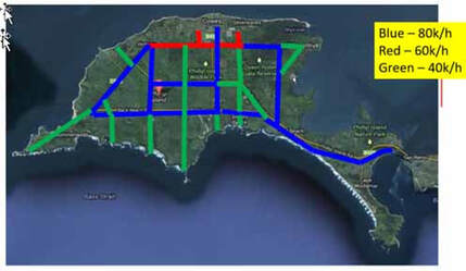
The option of using Backbeach Road as the main regional road has never been discussed. The traffic sketch shows traffic flowing to and from Cowes using Backbeach Road, following VLine and joining with buses to the Penguins and Racetrack traffic.
This would shift traffic to clash with traffic and pedestrians/bikes at Smiths. The problem already exists. Every day some 200 kids cross backwards and forward at Smiths/ Backbeach Road. With no traffic management it’s extremely dangerous.
By managing traffic flow, the viability of foot/bike bridges becomes more feasible. As the island becomes the key cycling / walking destination in Victoria, we’re going to need elevated bike tracks at Smiths Beach Road, at Backbeach Road and at Five Ways, with access to north-east and Cowes.
We will never eliminate cars but we must ensure that walkers and riders have priority.
How brave are we to deliver a world class destination based on the credo of “The environment is the economy”! Now the Distinctive Areas and Landscapes project enables us to think big.
My request to the council: rather than follow what has happened for 150 years, request discussions with the Roads Minister on a review of long-term traffic movements to decide on the best “corridor alignment”.
Phil Wright was a Bass Coast councillor from 2008-16. This is an edited version of a presentation he made to last week’s Community Connections session in Rhyll.