By Terri Allen
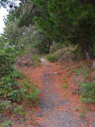
A TREASURE on the western edge of Wonthaggi, the Campbell Street bush is tucked between Campbell Street and West Area Road from Brown Street to Chisholm Road.
A TREASURE on the western edge of Wonthaggi, the Campbell Street bush is tucked between Campbell Street and West Area Road from Brown Street to Chisholm Road.
Historically it was the short cut between the mine precinct (5 Brace, Power House, Western Area, 9 & 10 shafts, mine workshops and the pay office) and the mining cottages to the south of the town. Prior to that it probably saw foot traffic from Tent Town to the Back Beach from 1909 to 1910 when weary miners sought solitude, sport and recreation. An aerial photograph from about 1950 indicates three clusters of buildings behind the pay office. Today it has many relics: pay office site, State Coal Mine bricks, concrete blocks and brickwork, rails, a fenceline, old cypresses and garden weeds.
As part of the Wonthaggi walking circuit it is a vital link, with tracks east-west and north-south, obviating the need to use Campbell Street and West Area Road which are rife with fast traffic and heavy trucks. To the west it adjoins the Baxters Wetland (and on to the Wonthaggi Heathland north, Back Beach – Baxter Beach – and Williamsons Beach).
Northwards it merges with the mining precinct (Powder House, 5 Brace, Western Area Haulage, Rescue Station) and the rail trail. Southward via Chisholm Road are the Wonthaggi Heathland and Harmers Haven, while Brown Street links with the Rifle Range or Tank Hill and Eastern Area.
Not only a walking track link, this bush is a corridor for wildlife: birds, insects, animals and seeds.
Many people use this small area of bush. Daily it has its coterie of bushwalkers, joggers, dog walkers, birdos, botanists and occasional horse riders and seed collectors. Often roos are heard thundering away through the bush, wombat calling cards are left and pobblebonks call from the northern pond. It is a great place for birdwatching, with 64 birds on our lists. It is safe from traffic, sheltered by grand old messmates and manna gums, ablaze with wildflowers in season, awash with surfboom and birdsong, soft underfoot, a tramp through history.
Unfortunately there are some drawbacks, the worst being the weed problem. Dozens of environmental weeds are present and still garden rubbish is being dumped, birds ferrying in seeds. Recent housing development has seen roadside vegetation damaged, especially the Xanthorrhoea, and the road has been built up considerably – whither the runoff? Motor bikes sometimes shortcut through to the motorcycle track, horses pug the track in wet periods and 4WD hoons damage the pondsite.
On a brighter note, the area is being monitored, bridal creeper dealt with, tracks maintained, an excellent map is available, the Baxter Wetland plantings are flourishing and in the future the sandpits are to become another wetland.
Since writing this I have learned that the area is on the agenda for an autumn hazard reduction burn.