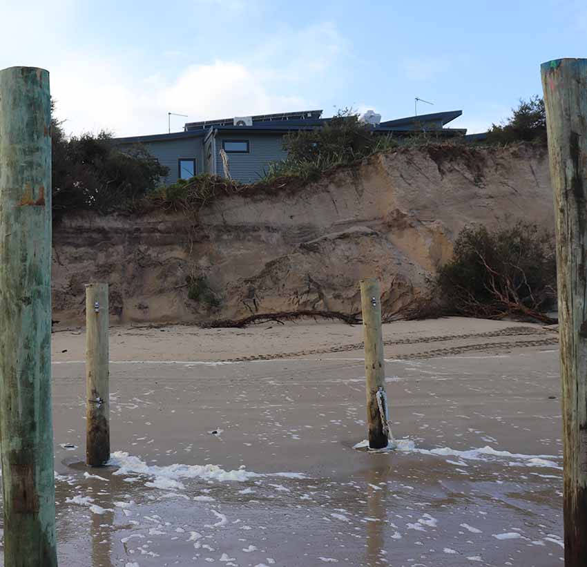
The scene this week after storm surges left the Inverloch Surf Lifesaving Clubhouse
just eight metres from the dune edge. Photos: Geoff Ellis
just eight metres from the dune edge. Photos: Geoff Ellis
By Catherine Watson
EMERGENCY works have begun to save the Inverloch Surf Lifesaving Club house after storm surges pounded the beach and left the clubhouse just metres from disaster.
South Gippsland Conservation Society vice-president Dave Sutton said it was the worst single event of erosion he had seen, with about a metre of sand dune disappearing between Thursday and Monday. By Monday, the beach was littered with foreshore vegetation exposed by the collapsing dunes and the clubhouse was just eight metres from the dune edge.
 Sand was shifted to create an emergency barrier.
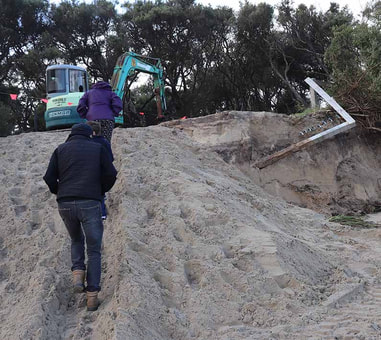
 The rapid erosion was the trigger point for an action plan to protect the clubhouse, determined 12 months ago by the multi-agency working group established to respond to the crisis.
On Tuesday an excavator and dump trucks were brought in to excavate sand from the beach to the east and dump it in front of the clubhouse as a temporary buffer while giant geotextile sandbags are constructed.
The council’s manager of sustainable environment, Deirdre Griepsma, said the working group had determined 12 months ago to implement harder engineering options once the gap between the edge of the dune and the clubhouse reached 10 metres.
“In the last 12 months approximately seven to eight metres of dune has been further eroded. The distance from the Inverloch Life Saving Clubroom to the dune edge is now around eight metres.”
Works to construct two new sturdier wet-sand fences with upgraded design was already under way and will continue. These works are expected to be completed in two weeks as an ongoing softer engineering option to complement other works.
Ms Griepsma said the worst of the storm surge season would end in the next six weeks.
“Strategic long-term discussions are continuing by the multi-agency Inverloch erosion working group. Discussions are centred on the recent rate of erosion, evidence-based decision making based on studies and accessing state and federal funding.”
Mr Sutton said the catastrophic loss of dune over the weekend was a wake-up call for the council to reconsider plans to remove dune vegetation to extend the Surf Parade pathway.
“Apart from not having much of a beach to look at when you get here, we will ultimately lose the pathway.”
Mr Sutton said the events of last weekend were the results of storm surges, a high tide and the long-term loss of sand from the beach.
“There’s now no run up. Whether it’s a storm surge or not, the waves are breaking close to the shore.” Sand level markers reveal the sand has receded by about 20 centimetres at Flat Rocks and Point Norman and about 90cms near the surf lifesaving club.”
Mr Sutton said the temporary sand barrier was doing its job. He also welcomed the new wet sand fence but said it needed to stretch the length of the beach.
“They’re protecting physical assets like the clubhouse but we’ve got to start putting a value on the vegetation and the value it affords the community.”
Cr Les Larke, a strong supporter of the pathway, dismissed Mr Sutton’s concerns about removing foreshore vegetation for the pathway.
“My views are unchanged. I reiterate that in my opinion the erosion issues and shared pathway are mutually exclusive. In other words, they are separate and very different from each other.
“I am confident council and other agencies will find a solution for the coastal erosion independent of the shared pathway project which has overwhelming community support.”
The people have spoken: Cr Les Larke